
Last modified: 2015-05-06 by francisco gregoric
Keywords: chubut | provincia del chubut | comodoro rivadavia | rawson | sarmiento (domingo faustino) | oil rig | sun: setting |
Links: FOTW homepage |
search |
disclaimer and copyright |
write us |
mirrors
The municipality of Comodoro Rivadavia (173,300 inhabitants in 2010;
566.81 sq. km) is located in central western Patagonia. Comodoro
Rivadavia is the most populous town in Chubut Province and Argentine
Patagonia.
Comodoro Rivadavia was founded on 23 February 1901. The municipality
was named for Commodore Martín Rivadavia (1852-1901), captain of the
corvette "Argentina" that surveyed the area in 1890, on behalf of
Colonel Luis Fontana, first Governor of Chubut. Martín Rivadavia was
the nephew of the statesman Bernardino Rivadavia (1780-1845), the
first head of state of Argentina (President of the United Provinces
del Río de la Plata, 1826-1827).
Oil extraction started in Patagonia in 1907, which boosted the
development of Comodoro Rivadavia, known today as the "National
Capital of Oil". The boom of the town attracted several immigrants;
Comodoro Rivadavia is the proud "Capital of Foreign Communities", with
an impressive list of registered foreign cultural associations
(Galician, Spanish, Argentine-Arab, Bolivian, Italian, Polish, Greek,
Yugoslav, Chilean, Portuguese, Basque, Asturian, Welsh, Paraguayan,
Bulgarian, South African, German, Czech and Slovak, Croat, Andalusian,
former USSR, Brazilian, and Israelite).
The Military Government of Comodoro Rivadavia was established by
Decree No. 13,941 of 31 May 1944, with jurisdiction on Chubut and
northern Santa Cruz. The military presence in the town dates back to
1935, when the 8th Infantry Regiment, founded on 13 July 1813 by
Manuel Belgrano, was relocated to Comodoro Rivadavia.
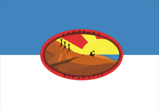
The flag of Comodoro Rivadavia is prescribed by Municipal Ordinance
No. 7,308 of 21 February 2001. The design proposed by Luis Eduardo
Hammerschmidt was unanimously selected on 26 January 2001 by the jury
made of Ms. Lila H. De Gastaldi, Mariela Córdoba and Liz Cristina López.
The flag is horizontally divided celeste blue-white with an oval
emblem (different from the municipal coat of arms), portraying the
local landscape, in the middle.
Celeste blue and white are the colors of both the country and the town.
The sun in the emblem's background represents the light of hope for
the local people.
The Chenque Hill [a 212 m high hill that divides the town in two
parts] is part of the landscape from which the town emerged.
The windpumps highlight the significance of the windpump park for the
town, recalling that wind is common in the area [the town, nicknamed
"Capital of the Winds", is the cradle of wind energy industry in
Argentina].
The oil wells represent the natural resource that attracted the first
inhabitants of the place.
The sea is another natural resource that contributed to the progress
of the town.
Ivan Sache, 03 Mar 2002 & 11 Aug 2013

The municipality of Rawson (22,493 inhabitants in 2001) is the capital of the Chubut Province.
Rawson was settled in in July 1865 by 150 Welsh colonists coming from Puerto Madryn. On 15 September 1865, Colonel Julián Murga, the
Military Commander of Patagonia, hoisted the Argentine flag in the new town. The new settlement was named Trerawson (in Welsh, Rawson
Village), subsequently shortened to Rawson, as a tribute to Guillermo Rawson (1821-1890) the Minister of the Interior (1862-1868) who had initiated the colonization. Antonio Oneto was appointed in 1876 the first Commissioner of the colony. The Chubut National Territory was established on 16 October 1884 by Law No. 1,532; Luis Jorge Fontana was appointed first Governor of the territory on 30 May 1885.The Municipal government of Rawson was established on 14 September 1888, presided by Gregorio Mayo. The Constitution adopted in 1957 established the Chubut Province, with Rawson as its capital.
The flag of Rawson, designed by Patricio Mouján, is prescribed by Municipal Ordinance No. 6,911, adopted on 31 August 2010 by the
Municipal Council.
The flag is horizontally divided white-green by a blue horizontal stripe ending in a blue triangle placed along the fly, charged with a yellow boat. In the middle of the flag is placed a white disk fimbriated black, charged with an iron bridge surrounded at the top by a half yellow sun and at the bottom by a gear wheel.
White represents purity and the plateau, while green represents the valley, the farms and hope in the future. The two colours symbolize the epos of the Welsh colonization.
The blue stripe and triangle symbolize river Chubut watering the town and flowing into the sea; the boat represents the fishing industry.
The disk represents the town. The bridge is the Poet's Bridge, inaugurated in 1918, representing union and the town of Rawson. The
sun represents future and the Chubut Province, while the gear wheel represents industry.
Ivan Sache, 23 Nov 2012
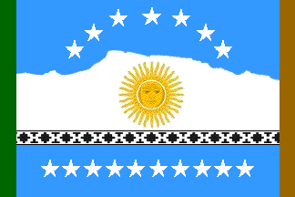
The municipality of Sarmiento (8,028 inhabitants in 2001) is located in the extreme south of the Chubut Province (Patagonia), 160 km east of Comodoro Rivadavia. Founded on 21 January 1897 as a Welsh colony and, therefore, one of the oldest towns in Patagonia, Sarmiento is the capital of the Department of the same name (14,563 sq. km). Sarmiento is the closest town to the "Bosque Petrificado José Ormachea" (Petrified Forest José Ormachea), the biggest fossil forest in the world.
The town, formerly known as Colonia Sarmiento, was named for Domingo Faustino Sarmiento (1811-1888), President of the Republic in 1868-1874.
The flag is modelled on the Argentine national flag, the white stripe being shaped like Mt. San Bernardo, the geographic identification of the town. The white stripe is separated from the lower celeste blue flag by a "Tehuelche guard", black with X-shaped white elements, recalling the native peoples who already lived there 12,000 years ago.
The 17 white stars (seven forming an arch in the upper part of the flag, another ten forming a horizontal line in the lower part of the flag) represent the 17 settlements at the origin of Sarmiento and the melting pot constituted by the town.
Along the hoist, a green vertical stripe represents the fertile valley surrounding the town; along the fly, a brown vertical stripe
represents the Patagonian steppe. The two "guards" located on both ends of the flag are a symbol of protection, modelled on the concept of the protection halo provided by the gods shown on the natives' cloth.
The flag is hoisted in the room of the Municipal Council, together with the flags of Argentina and of the Chubut Province. It is also used outdoors in official ceremonies.
Ivan Sache, 1 Oct 2012
Anything below this line was not added by the editor of this page.