 image by André Pires Godinho,
5 November 2005
Last modified: 2012-03-03 by ian macdonald
Keywords: pará | ourilândia do norte |
Links: FOTW homepage |
search |
disclaimer and copyright |
write us |
mirrors
 image by André Pires Godinho,
5 November 2005
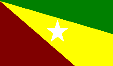
Three fields radiating from the upper hoist: green in the upper fly, yellow across toward the lower fly, maroon in the lower hoist; in center a white star on the yellow field.
The municipality of Ourilândia do Norte (27,564 inhabitants in 2010;
13,826 sq. km) is located on southeastern Pará, 650 km of Belém. Ourilândia
do Norte was established in 1980 within the Tucumã Project. Following the
discovery of fertile soils and plenty of gold in the region, the Tucumã
Project allowed the selection of colonists among applicants who could not
afford the purchase of a plot of land. The first colonists built huts near
the sentry box (Portuguese, "guarita") set up by the Director of the Tucumã
Project; accordingly, the first settlement was named Guarita. Originally a
district of the municipality of São Félix do Xingu, Ourilândia do Norte was
made a municipality by State Law No. 5,449 of 10 May 1988, published on 12
May 1988 in the State official gazette. State Law No. 6,066 of 14 August 1997
modified the border of Ourilândia do Norte with the municipality of Água Azul
do Norte.
Ivan Sache, 8 February 2012
 image by Ivan Sache,
8 February 2102
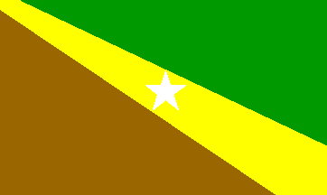
The flag shown on the municipal website is slightly different
from the one shown at the top of this page.
http://www.ourilandia.pa.gov.br/portal1/municipio/hino_brasao.asp?iIdMun=100115086
Ivan Sache, 8 February 2012