 image located by Ivan Sache, 29 February
2012
image located by Ivan Sache, 29 February
2012Source: http://tibagi.pr.gov.br/site/modules/cidade/index.php?pagenum=4

Last modified: 2012-03-16 by ian macdonald
Keywords: parana | tibagi |
Links: FOTW homepage |
search |
disclaimer and copyright |
write us |
mirrors
 image located by Ivan Sache, 29 February
2012
Source:
http://tibagi.pr.gov.br/site/modules/cidade/index.php?pagenum=4
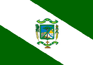
The Flag of Tibagi is a green-white-green descending diagonal triband with the arms in the center on the white band. According to http://tibagi.pr.gov.br/site/modules/cidade/index.php?pagenum=4 it was introduced 9 February 1988 by Law No. 1.155.
The municipality of Tibagi (19,332 inhabitants in 2010; 3,109 sq. km) is
located in central east Paraná, 230 km of Curitiba. The municipality is made
of the town of Tibagi proper and of the districts of Caetano Mendes and Alto
do Amparo. Tibagi is named for the sinuous river Tibagi, known in the 18th
century as "the marvellous river" or "the true eldorado". Gold, diamond and
gems transported by the river attracted all kinds of adventurers; the first
permanent settlement established in the region seems to date back to 1782,
when Antônio Machado Ribeiro, aka Machadinho ("The Man with the Hatchet"),
moved with his family from São Paulo to the Fortaleza estate, owned by his
associate José Felix da Silva; subsequently, Machadinho moved again to the
banks of the river, on the today's site of the town of Tibagi. Ana Beja,
Machadinho's niece, built the chapel that was the center of the emerging
town. Law No. 15 of 6 March 1846 established the parish of Tibagi. The
municipality of Tibagi was established by Law No. 302 of 18 March 1872 and
inaugurated on 10 January 1873. Since then, several new municipalities have
been established in the Paraná's "New North", which significantly decreased
the area of the municipal territory
The symbols of Tibagi are prescribed
by Municipal Law No. 1,155 of 9 February 1988.
http://tibagi.pr.gov.br/site/modules/mastop_publish/?tac=Simbolos&PHPSESSID=ad5a7aa5f7a69d53868dd71583378428
Ivan Sache, 29 February, 2012