 image by Dirk Schönberger, 31
January 2012
image by Dirk Schönberger, 31
January 2012Source: http://www.pmcoxilha.rs.gov.br/cidade/simbolos

Last modified: 2012-03-28 by ian macdonald
Keywords: rio grande do sul | coxilha |
Links: FOTW homepage |
search |
disclaimer and copyright |
write us |
mirrors
 image by Dirk Schönberger, 31
January 2012
Source:
http://www.pmcoxilha.rs.gov.br/cidade/simbolos
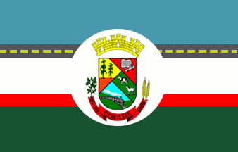
Horizontally divided blue-white-green, with a narrow dark grey stripe with a yellow dashed line along its centre between the blue and white stripes, and a narrow red stripe between the white and green stripes, and the municipal arms in the centre in a white disk.
Official website at
http://www.pmcoxilha.rs.gov.br
Dirk Schönberger,
31 January 2012
The municipality of Coxilha (2,826 inhabitants in 2010; 423 sq. km) is located in northwestern Rio Grande do Sul, 320 km of Porto Alegre. Coxilha originates in the Coxilhas estate, built on a "coxilha" around 1840 by Francisco de Barros Miranda e Manoel de Souza. The "coxilhas" are isolated, rounded hills, typical of the Rio Grande do Sul landscape; the first colonists built their huts on top of these hills as a protection against the Coroados natives' raids. The establishment of the railway line, built in 1905-1911, favoured exploration, industrialization and trade of araucaria timber. The araucaria Gilded Age lasted from 1910 to 1950, when araucarias were used as export timber and fuel for the locomotives. In the 1930-1940s, Coxilha was a main center of exportation of araucaria timber, with different workshops processing the trees to make boxes and boards. With the mechanization of agriculture, Coxilha became a great producer of wheat in the middle of the 1960s; soybean cultivation started in the 1970s. Wheat production was even increased in the 1980s: four out of the six main wheat producers in Brazil were from Coxilha. The municipality of Coxilha was established on 20 March 1992, following a plebiscite organized on 10 November 1991.
The flag of Coxilha is prescribed by Municipal Law No. 29 B of 16 July 1993. The flag shall be in size 14 cm x 20 cm (sic). Green represents the fields and forests, as well as agriculture and cattle-breeding, the main resources of the municipality and a main source of income for its inhabitants. Blue represents the sky over the beautiful "coxilhas" and a progressivist future for the municipality. White, a symbol of peace, unites the agricultural progress with the beauty of the universe; peace is requited for the good development and progress of Coxilha. The two thinner stripes symbolize the transportation of progress through asphalted roads and roads of lesser importance.
The coat of arms of Coxilha, designed by Adir dos Santos Oliveira, is
prescribed by Municipal Law No. 5 of 5 February 1993.
The shield is quartered per "balão" into four sectors. The upper right
sector shows an open book, a compass and a ruler on a red background,
representing education. The upper left sector shows maize on a yellow
background, representing agriculture and maize production. The lower
right quarter shows cattle in a field, representing cattle-breeding.
The lower left quarter shows "coxilhas" in the background and a train
representing the transportation of the products of the municipality.
All the elements are represented with the colors of the flag of Rio
Grande do Sul.
The red scroll place below the shield is inscribed with the name and
date of establishment of the municipality. The scroll ends dexter with
a branch of soybean and sinister with two wheat spikes.
The shield is surmounted with a mural crown made of three fortresses;
the crown represents the town of Coxilha proper while the fortresses
represent the settlements of the hinterland of the municipality.
http://www.pmcoxilha.rs.gov.br/cidade/simbolos
Ivan Sache, 20 March 2012