 image by Dirk Schönberger,
15 November 2012
image by Dirk Schönberger,
15 November 2012Source: http://www.itapetininga.sp.gov.br

Last modified: 2012-12-09 by ian macdonald
Keywords: sao paulo | itapetininga | stripes: 4 (horizontal) | canton (white) | stars: 4 (blue) | coat of arms |
Links: FOTW homepage |
search |
disclaimer and copyright |
write us |
mirrors
 image by Dirk Schönberger,
15 November 2012
Source:
http://www.itapetininga.sp.gov.br
Other sites:
Itapetininga was founded in 1724 by pioneers coming from Sorocaba. Around 1760, a group of Portuguese pioneers led by Domingos José Vieira left the early settlement to establish a new one, on a height surrounded by two rivers. The two rival settlements asked for the status of "vila". Simão Barbosa Franco was appointed to select the site of the new town according to some historians, Domingos José Vieira offered him a mule to "convince" him that his own settlement was most suitable to establish a new town. Anyway, the "vila" of Nossa Senhora dos Prazeres de Itapetininga was established on 5 November 1770 with the celebration of a mass by Father Inácio de Araújo Ferreira. The municipality of Itapetininga was established on 17 July 1852 by Law no. 11.
The name of Itapetininga comes from Tupi-Guarani; philologists have found three possible meanings: - "Itáapé-tininga", "a path paved with dry stones" or "a dry path paved with stones"; - "Itape-tininga", "a flat stone", "a flagstone" or "a dry pavement"; - "Itá-pe-tininga", "made of dry stones".
The symbols of Itapetininga are prescribed, without further description, as the symbols "representative of the culture and history" of the municipality, in Article 6 of the Municipal Constitution, last amended on 26 September 2011
http://www.camaraitapetininga.sp.gov.br/camara/arquivo/lei_organica/lei_organica.pdf - Municipal Constitution
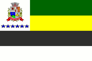
The flag is prescribed by Municipal Law No. 4,023 of 15 April 1997. The flag is horizontally divided green-yellow-black-white with a white square canton charged with the municipal coat of arms above six blue stars. Black and white represent São Paulo State. Green and yellow represent the Union [Brazil]. The coat of arms represents the municipal government. The six stars represent the districts of Varginha, Conceição, Morro do Alto, Tupi, Rechã and Gramadinho.
Photo of the flag, 22 June 2011
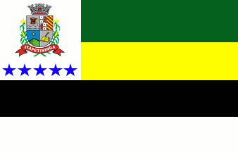
The previous flag of Itapetininga, prescribed by Municipal Law of 27 August 1980, had only five stars below the coat of arms. The first flag of Itapetininga, prescribed by Municipal Law No. 769 of 7 July 1961, had only four stars below the coat of arms.
The coat of arms is prescribed by Municipal Law No. 1,118 of 26 October 1964 (oddly enough, the coat of arms appear to have been approved later than the flag that shows it). "A shield of the times of the Portuguese Empire, quarterly 1. Argent a jacket (old cloth) proper, an axe and a gun or, symbolizing the early colonists from Sorocaba Below the jack, two white wavy stripes representing the two rivers that waters the hill where the town emerged. 2. Quarterly, with two red leopards on a field argent and two white field with five ermine spots. Argent is the colour of metals, arms and nobility, while red (gules) is the colour of struggle and triumph and ermine [part of the sentence missing]. 3. A green hill, of the colour of the forests on blue, the colour of the sky. A golden star symbolizing the independent organization of Itapetininga. 4. Argent a book and quill or, symbolizing culture, faith, hope and prosperity. The shield surmounted by a four-towered and four-gated mural crown argent, symbolizing order, peace, safety and autonomy. The symmetry indicates balance and harmony that prevail among the inhabitants. The shield supported by two plants of maize fructed and crossed below the scroll, meaning the crop that made famous the name of Itapetininga. Below the shield a red scroll, of the colour of struggle and triumph, inscribed with the toponym 'ITAPETININGA' in letters argent."
http://portal.itapetininga.sp.gov.br/sobre/1206/Simbolos+Oficiais -
Municipal website
Ivan Sache, 17 November 2012
 image by Dirk Schönberger,
15 November 2012
Source:
http://portal.cnm.org.br/sites/7100/7179/bandeiras/sp/bandeira/bandeira_itapetininga.gif
The variants show different numbers of blue stars.
Official website at
http://www.itapetininga.sp.gov.br. Presumably these are historical variants,
the number of stars showing the number of barrios or something.
Dirk Schönberger,
15 November 2012
You guessed it right, except that the stars stand for districts and
not barrios. Here, the three flags have been used (or at least prescribed), in
three successive periods of time.
Ivan Sache, 17 November 2012
Located in the "eastern cone" of the state, in the upper Paranapanema River basin 178 km from São Paulo. The
source site provides no explanation of the flag, which has four horizontal stripes, green, yellow, black, and
white, with the municipal coat of arms above four blue stars on a white canton. Green and yellow presumably
are for Brazil and black and white for the state of São Paulo.
Source:
www.citybrazil.com.br/sp/itapetininga/geral.htm
Joseph McMillan, 4 September 2002