This page is part of © FOTW Flags Of The World website
Westervoort (The Netherlands)
Gelderland province
Last modified: 2014-06-28 by andrew weeks
Keywords: westervoort |
Links: FOTW homepage |
search |
disclaimer and copyright |
write us |
mirrors
 Shipmate Flagchart : http://www.flagchart.net
Adopted 11 Oct 1976; design: Stichting Banistiek en Heraldiek.
See also:
Westervoort municipality
Population (1 Jan 2003): 16.162; area: 7,85 km². Settlements: Westervoort
(seat).
Westervoort is southeast and virtually a suburb of Arnhem. The village
existed already in the 8th century AD. It was the stronghold of the Hamerden
family. The fortress north of the IJssel river was part of the IJssel-line.
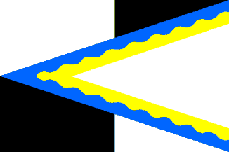
Flag: Quartered of white and black, with over all a fly-triangle, reaching
into the hoist, of white with along top and bottom a seam of 1/7 flagheight
of two wavy connected stripes in yellow (outside) and blue (inside).
Adopted 11 Oct 1976 by municipal resolution; design: Stichting Banistiek
en Heraldiek.
Jarig Bakker, 21 Oct 1999
Westervoort Coat of Arms
![[Westervoort Coat of Arms]](../images/n/nl-ge)wt.gif) from the Westervoort municipal site.
from the Westervoort municipal site.
Granted 28 Apr 1975.
 Shipmate Flagchart : http://www.flagchart.net

 Shipmate Flagchart : http://www.flagchart.net
![[Westervoort Coat of Arms]](../images/n/nl-ge)wt.gif) from the Westervoort municipal site.
from the Westervoort municipal site.