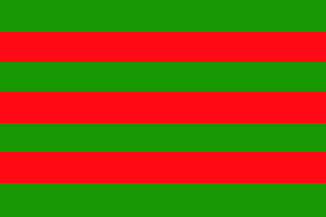
image by Pascal Gross, 19 June 2000

Last modified: 2015-01-23 by zoltán horváth
Keywords: panama | chiriqui |
Links: FOTW homepage |
search |
disclaimer and copyright |
write us |
mirrors

image by Pascal Gross, 19 June 2000
Districts:
Municipalities:
See also:
Province of Chiriqui. Its flag could be seen at the bottom of
the page available at <www.koco.net> (defunct).
Pascal Gross, 19 June 2000
On 26 May 2004, the 155th anniversary of the foundation of the
province was celebrated in Barú, with the participation of
delegations from the schools and colleges from the 13 districts (distritos)
of the province. The celebration started at 8:00 with the raising
of the national flag and the provincial flag in the Government of
the province. The traditional cremacion de banderas took
place there, but I don't know what it is exactly, some
traditional flag burning?
I skip the long list of the local politicians who attended the
ceremony, only mentioning the presence of recently elected (3 May
2004) president of the Republic Martín Torrijos, the son of the
former, controversial president General Omar Torrijos
(1968-1981). At the end of the celebration, Franklin Valdés alcade
(mayor) of Baru, offered the provincial banner to Juan Serrano, alcade
of Boquerón , where the celebration of the 156th anniversary of
the province shall take place next year.
The whole story and pictures of the celebration, unfortunately
not showing the flag, can be read, in Spanish, in La Prensa
(Panama) at <www.prensa.com>.
The article by Sandra Alicia Rivera includes more details on
Chiriqui, which I am summarizing now.
History - The name of the province comes from cheriquí,
a word used by the natives to designate the highest cumbre
(?) of the cordillera and meaning "valley of the Moon and
land of the two big waters". Another version says that
Chiriqui was the name of a native famous for his strength. Law 62
of 26 May 1849 officially established the provincial
administration of Chiriqui, made of the nine districts of Alanje,
Boqueron, David (capital city), Dolega, Gualaca, San Félix , San
Lorenzo, San Pablo and Remedios. The districts of Baru, Boquete,
Renacimiento and Bugaba were later incorporated to the province.
Geography (supplemented with data from Encyclopaedia Universalis
Yearbook, 1998) - The province of Chiriqui is located in the west
of the country. It is bordered on west by Costa Rica, on north by
the province of Bocas del Toro, in the east by province of
Veraguas and in the south by Pacific Ocean. It has an area of
8,653 sq. km and a population of c. 370,000 inhabitants (second
most inhabited district in Panama). The capital city of the
province is David, with c. 65,800 inhabitants (third largest city
in Panama), whereas Baru has c. 45,000 inhabitants (fifth largest
city in Panama).
Economy - The province has a big, diversified agricultural
production. There is alos a significant industrial acticity in
the province, whose products can be shipped from the ports of
Charco Azul and Pedregal. Chiriqui is also a main destination for
national and international tourism. The most visited place in the
province is Volcan Baru (3,475 m), located in the Cordillera of
Talamanca. In the highlands of the province is located the place
called "Valley of Flowers and Everlasting Spring", in
the district of Boquete.
Ivan Sache, 29 May 2004
I found a photo with
probably anniversary version of a flag with coat of arms in
middle at <www.elchiricano.com>.
Another photo here.
Coat of arms can be seen here.
Aleksandar Nemet, 20 January 2010
Chiriquí has 13 districts (see above).
Source:
http://en.wikipedia.org/wiki/Chiriqu%C3%AD_Province
Rob Raeside, 03 August 2014
chiri.gif)
image by Fred Drews, 03 August 2014

image bby Jaume Ollé, 21 June 2000
Colors of the flag were originated in 1965 when the indians,
led by Samuel Gonzalez proclaimed the Chiriqui republic. This new
state was short lived and national Guard supresed the republic in
few days.
Jaume Ollé, 21 June 2000