Last modified: 2013-12-05 by zoltán horváth
Keywords: karachay-cherkessia | caucasus | cossack | doubt | mountain | sun: setting | sun: 24 rays | zelenchuk-urupsk | circassian |
Links: FOTW homepage |
search |
disclaimer and copyright |
write us |
mirrors

(Note: You need an Unicode-aware software and font to correctely view the cyrillic text on this page. See here transliteration details).
Karachay-Cherkessia is in the north Caucasus,
it borders Kabardino-Balkaria
to the east, and Abkhazia and
Georgia to the south.
The Karachay and Circassian languages are very
closely related to Balkar and Kabardian respectively.
Vincent Morley, 19 Nov 1997
In 1920, the Bolsheviks set up the Mountain Autonomous Soviet
Republic in the north Caucasus, which included the lands of the Cherkess
(Circassians) and Karachay, but 2 years later this fell apart and a
separate Karachay-Cherkess region was established. In 1926, this was
further subdivided, and the two peoples had their own regions. In 1936,
they were merged yet again, but 8 years later, in 1944, direct rule was
imposed by Moscow because of collaboration between the north Caucasus
peoples and the Germans. Local autonomy was not restored until 1957.
Stuart Notholt, 17 Sep 1995
The book Winds of Change - Flags and Coats of Arms of the Russian Republics [r4f96] is not clear enough: Not only the text of both laws is confuse (the current law was approved while the book was in print and was thus added at the end), but also the color plate shown follows neither of them…
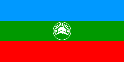
In fact, the law of 1994.02.03 (N 76-XXI) states that the flag is 1:2 with three horizontal stripes of light blue, green and red, further saying that «in the middle of the green stripe, in its full width, there is a light circle (ring) with the sun rising from behind mountains, with five doubled wide long and six thin short beams.» (Translation from [r4f96].) The curious color description of the central emblem, «light», is shown in the color plate as white. On the emblem, a sun rising from behind a mountain, showing ten larger and six smaller beams — the larger beams are described as being double. If complete (4 to 8 o’clock is obscured by the mountain), this sun would show 24 rays: 16 large beams arranged in pairs interpolated with 8 smaller ones.
António Martins, 12 Apr 2000
Blue symbolizes peace, kind motives and quiet.
Green represents nature, fertility and wealth.
Red is for the warmth and unity of the people.
The mountains in the centre recall the scenery
of the republic.
Vincent Morley, 19 Nov 1997,
quoting [rya97]
The design of the flag also seems to suggest the
close ethnic links between this republic and
Kabardino-Balkaria.
Vincent Morley, 19 Nov 1997

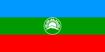
The law of 1996 (N 146-XII, adopted by the local parliament in 1996.07.26
and signed by the local President in 1996.08.02) gives exactely the same
description, omitting only the words «in its full width». (I confirmed
this both in the english translation and in the russian original version,
as given on the book.) Other differences may exist in the images that
accompaign the laws, but this is not refered on the book. The two laws are
though very different — if not in content, at least in arrangement of the
articulate (flag description is on points 2 to 4 in the old law and in
Clause 1 in the new).
The main difference between the old and new flags seems to be the size of
the emblem: the 1994 version had it strached to the full height of the
grren stripe, while the current flag shows it slightly smaller.
António Martins, 12 Apr 2000

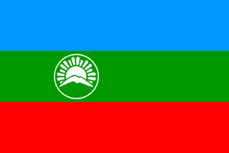
The image in Winds of change
[r4f96] is though quite different from both
legal prescriptions, showing a 2:3 flag with the central emblem placed
offset to the hoist.
As for the ratio and emblem placement differences, for wich there is no
support on either law, I can only speculate that the 1:2 image was
incorrectely cropped to 2:3 from the fly side: the position of the emblem,
centered on a vertical line 1/4th from the “hoist”, seems to corroborate
this…
António Martins, 12 Apr 2000

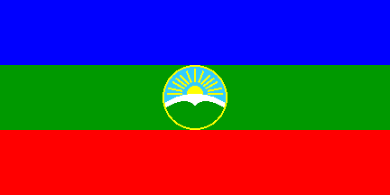
As shown on [rya97].
António Martins, 12 Apr 2000
In 1992 or 1993 some regions self upgraded
to constituent republics, and used ephemeral unofficial flags. One of the
main republics was Zelenchuk-Urupsk, flag unknown.
Jaume Ollé, 15 Apr 2000
Zelënoĉukskaâ and Urup are located in Karachay-Cherkessia. I guess
this entity was promoted by local Kossacks,
since the region seems to be populated by them — at least both counties
have their “center” (capital) on stanicas, i.e. cossack
towns.
António Martins, 18 Apr 2000