Last modified: 2014-06-14 by ian macdonald
Keywords: fao | timor | map | star: 5 points (white on black) |
Links: FOTW homepage |
search |
disclaimer and copyright |
write us |
mirrors
In 1975-2000, during the
Indonesian occupation, selecting a flag to
unofficially represent the territory posed a political-vexillological
challenge:
António Martins, 05 April 2007
Although the red flag
of the Democratic Republic of East Timor,
proclaimed by FRETILIN
in 1975, have gained a very broad acceptance
and is often used to symbolize East Timor even
out of any political context (i.e., giving
no preference to any timorese
party), sometimes the more careful use instead
of it more “neutral” designs.
António Martins, 05 December 1999
 image by António Martins
 image by Jorge Candeias, 04 January 2000
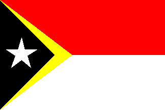
The Portuguese newspaper Correio da Manhã published
graphics produced by the Spanish company GRAFÍA / INTERPRESS.
This company invented a flag to go with these graphics, a
total absurdity consisting of the Indonesian
bicolour with the yellow and black triangles from the
DRET flag at hoist. This thing would
be offensive to everybody in East Timor, independentists and
integrationists alike. Yet the Spaniards kept on putting it in
their illustrations and the Portuguese newspaper kept on
publishing it throughout the whole crisis…
“journalists”, they say…
Jorge Candeias, 04 Jan 2000
A variation of this [map on plain background] appears in the news related
to Timor of one of the Portuguese newspapers: the outline of the territory
merged with an arc with an outer diameter about 80% of what should be to
enclose the map.
Jorge Candeias, 27 Oct 1999