image by Ivan Sache, 25 July 2015

Last modified: 2015-08-06 by zoltán horváth
Keywords: nueva esparta | macano | juan griego |
Links: FOTW homepage |
search |
disclaimer and copyright |
write us |
mirrors

image by Ivan Sache, 25 July 2015
See also:
This municipality has known under two names, Macanao (not Macano) and Península de Macanao. The municipal website simply uses Macanao, which must, therefore, be the most commonly used name.
The municipality of Macanao (aka Península de Macanao; 26,423 inhabitants in
2011; 330.7 sq. km, therefore the largest municipality in Nueva Esparta by its
area) forms the western part of Margarita Island (the largest island of the
insular State of Nueva Esparta). The municipality is made of the Parishes of
Boca del Río (municipal capital) and San Francisco de Macanao (capital, Boca de
Pozo, aka Macanao) and of the villages of Boca de Río, Guayacancito, El Horcón,
El Manglillo, Curichicual, Párate Bueno, Punta Arenas, Boca de Pozo, Robledal,
El Tunal, San Francisco de Macanao, Manzanillo, Arenas, El Maguey and El Saco.
The peninsula of Macanao was once an island; sedimentation progressively formed
the narrow isthmus that connects it to Eastern Margarita. The bridge over the
Restinga laguna, planned on 4 September, was inaugurated on 17 February 1963,
Macanao is named for a Guaquerí cacique. Boca de Pozo is one of the oldest
settlements in the municipality. The cattle estates of Robledal and Chacaracual
were established there in 1660. Agriculture was established in 1841, on the soil
hitherto considered as sterile. Urbanization started in 1844 when Robledal was
relocated to its today's site.
The municipality of Península de Macanao was established, as a District, by a
Decree adopted on 14 December 1974 by the Legislative Chamber of the State of
Nueva Esparta. Full municipal status was granted on 29 January 1988, with
separation from the municipality of Díaz.
Ivan Sache, 25 July 2015
Flag of Macano municipality (capital: Plaza Paraguachi) can be
seen at <macanao-nuevaesparta.gob.ve>.
Dov Gutterman, 3 June 2005
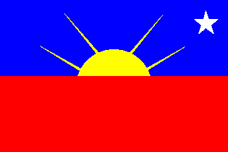
The flag of Macanao, designed by Heraclio Narváez, is horizontally divided
blue-red with a yellow rising sun and a white star in upper right canton. The
blue stripe represents the sea surrounding the municipality, the main source of
income for the fishers. The red stripe represents blood shed by the Guaquerí
natives. The yellow sun represents wealth; its four rays stand for 4 May, "the
day Margarita joined the battle of Matasiete [Margarita Island, a Republican
stronghold, was invaded in 1817 by the Spanish troops commanded by General
Morillo; on 31 July 1817; Morillo was defeated in Matasiete.]
The white star is the fisher's eternal guidance.
Source:
http://alcaldiademacanao.com.ve/bandera-municipal/
Ivan Sache, 25 July 2015
o-mac.jpg)
from <http://alcaldiademacanao.com.ve/escudo-municipal/>
updated link provided by Ivan Sache, 25 July 2015