 Shipmate Flagchart : http://www.flagchart.net
adopted 17 Apr 1958

Last modified: 2014-06-28 by andrew weeks
Keywords: hoogeveen |
Links: FOTW homepage |
search |
disclaimer and copyright |
write us |
mirrors
 Shipmate Flagchart : http://www.flagchart.net
adopted 17 Apr 1958
 image from Ralf Hartemink's site.
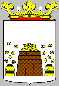
Granted 10 Nov 1819. The Hoogeveen Coat of Arms is a pile of peat covered
in straw and on both sides there are two beehives and an axe. The beehives
date from the time when the inhabitants of Hoogeveen used to dig up empty
peat fields to grow "boekweit". Boekweit contains alot of honey. Large
numbers of Hoogeveeners became beekeepers. There were periods when the
beekeepers in Hoogeveen produced more than 10,000 kilos of honey per year.
![[Elim village flag]](../images/n/nl-dr_el.gif) by Jarig Bakker, 17 Jan 2004
by Jarig Bakker, 17 Jan 2004
Elim is a village in Hoogeveen municipality, Drenthe province.
Flagdescription: rectangular, divided diagonally from bottom left to
top right, in two fields, red at the hoist and white at the fly; in the
center over all a blue disk charged with two black palmtrees, standing
on a terrace of the same, behind which issuing from behind the leaves a
small white sun.
Confirmed by the Vlaggen Documentatie Centrum Nederland on 30 april
1998.
Elim was founded at the junction of two canals, and developed by the
peatdigging, which started c. 1880. Ditches were dug and peat was transported
on ships. Apart from the ditches the "Dwarsgat" was dug, a wide
ditch or cross-channel connecting the other ditches. In 1786 a community
of seasonal workers started to live here in small cottages, and Dwarsgat
has long been the name of the settlement.
The official name for Hollandscheveld, incl. Dwarsgat was then "Wijk
E". Later Dwarsgat and environment got the name "Wijk H". Elim became an
official village on 1 May 1924.
The name "Elim" refers to an oasis which the people of Israel visited
after the exodus out of Egypt during the journey through the desert to
the Promised Land. According to the Book of Exodus Elim consisted of twelve
wells and seventy palmtrees. The palmtree has also been used on the flag
of Elim.
Source: Derkwillem Visser's "Gemeentevlaggen en wapens Koninkrijk
der Nederlanden", 2001; the Hoogeveen
municipal website.; the Elim
village-site.
Jarig Bakker, 17 Jan 2004
![[Noordscheschut flag]](../images/n/nl-dr_ns.gif) by Jarig Bakker, 17 Jan 2004
by Jarig Bakker, 17 Jan 2004
Noordscheschut is a village in Hoogeveen municipality, Drenthe.
The main item is a drawbridge. Noordscheschut = northern lock (in the
Hoogeveensche vaart - canal); the lock is topped by a drawbridge, which
dominates the village.
The flag was an initiative of the society for village interests (Plaatselijk
Belang Noordscheschut); designed in 1998 by Johnny Jonker; adopted June
1999.
Source: letter to Mr. Hans van Heijningen by Roel Benjamins; Noordscheschut's
homepage.
Jarig Bakker, 17 Jan 2004