 Shipmate Flagchart : http://www.flagchart.net
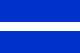
adopted 19 Apr 1955; design: Kl. Sierksma

Last modified: 2014-10-04 by andrew weeks
Keywords: wunseradiel |
Links: FOTW homepage |
search |
disclaimer and copyright |
write us |
mirrors
 Shipmate Flagchart : http://www.flagchart.net
adopted 19 Apr 1955; design: Kl. Sierksma
![[Wûnseradiel Coat of Arms]](../images/n/nl-fr)wu.gif) from Ralf Hartemink's site.
from Ralf Hartemink's site.
Granted 25 Mar 1818. According to tradition this deer was chased from
Zevenwouden (southeast Fryslân) all the way to Wûnseradiel,
where it was caught.
In spring 1955 the municipal council of Wûnseradiel decided to
celebrate Liberation Day (5 May) in a special way: to present every village
with its own Coat of Arms and flag. Mr. K. Sierksma was invited to design the flags.
The villages were grouped according to geographical location and means
of income:
1. Seven meadowvillages around the old lakes: Greonterp
(now part of Wymbritseradiel), Tsjerkwerd, Dedgum, Allingawier, Exmorra,
Hieslum, Parrega.
2. Seven villages along the old seadike: Ferwoude, Gaast, Idsegahuizum,
Piaam, Makkum, Cornwerd, Zurich.
3. Eight inland meadowvillages:
a. central villages: Wons, Schraard, Longerhouw, Schettens
b. villages on the municipal border: Lollum, Hichtum, Burgwerd, Hartwerd.
4. Four agricultural villages: Kimswerd, Pingjum, Arum, Witmarsum
5. And the new village: Kornwerderzand (on the Enclosuredam)
The municipal flag is: Three horizontal stripes of blue and white, proportioned
5:2:5.
The white stripe symbolizes the division of the municipal territory.
In ancient times the mighty river Marne split the municipality in two,
from Bolswrd city towards the Waddenzee, running between Witmarsum and
Pingjum, through the bed of the present "Bidlersfeart" (Beggars
canal) towards Dijksterburen, where it streamed into the Waddenzee/Zuiderzee.
In those days two "grietmannen" (mayors) ruled over Outer-Wonseradeel
and Inner-Wonseradeel (outside and within the dikes).
The Marne-river became a fertile region. Its bed narrowed to a small
canal or ditch. The division of Wûnseradiel however remained the
same: meadows and agricultural fields. A new division was created by the
construction of the National Route Numéro 43. Nevertheless the municipality
retained its unique character.
Village flags and -Coats of Arms.
The flags were mostly designed some ten years before the village-arms.
The designs were inspired by the division mentioned above; in some Coats of Arms
some exceptions were made. For Coats of Arms several arms were used of families,
who had lived on old "states" or "stinsen" (fortified stately
houses).
Flags contain diagonal stripes for meadows, and rectangles for agriculture
(Wûnseradiel is the only Frisian municipality split into a
"gershoeke" (grass) and a "bouhoeke" (clay)); furthermore
some elements will explain itself, like clover, corn-ears, and images of
animals. To underline the municipal belonging all flags have a narrow vertical
strip at the hoist with the colors of the municipal flag.
The villageflags of the first group - meadowlands around the old lakes: The old lakes were the Makkumer, Parregeaster, Sins-, and some other tiny lakes; all have been made dry. Their white waves, restlessly attacking the reedbanks, have disappeared; the white swanflowers floating on the water have made place for lushy meadows. The sky remained blue in mild springs. Green the grass grows in the meadows; red is the color of thriving weedss on black peat-soil. The red waterlilyleaf on the red field symbolizes the old lakes. Three villages have been sorted in pairs with the same colors, as they are very often mentioned as twin-villages. Only Greonterp is on its own.
The second division of the Wûnseradiel villages concerns the villages
along the dike against the old Zuiderzee, now IJsselmeer/Waddenzee. Four
of those villages were protected by the "Polderboard" "Westergo's IJsselmeerdijken"
- represented by the diagonal stripe from hoist-bottom to fly-top. The
other villages were protected by the Polderboard "Der Vijf Deelen Zeedijken
Buitendijks" - symbolized by a diagonal stripe from hoist-top to fly-bottom.
Since the construction of the Enclosuredam the southern villages don't
feel the threat of the sea as much as the villages north of the Enclosuredam.
The colors change in the flags from soft green to full red.
In Idsegahuizum the colors are blue and yellow, signifying that it
is an agricultural village (yellow = corn) amongst grassy villages. Makkum's
Coat of Arms (a golden mermaid rising from the green sea) is represented on the
flag by the colors yellow and green.
The last village Zurich calls out DANGER with burning red as the storm
gathers the water for an attack against the dike.
Source: "It Beaken", Magazine of the Frisian Academy, Dec 1969.
Jarig Bakker, 24 Sep 2003