Last modified: 2014-06-01 by zoltán horváth
Keywords: two shades of blue | magadan | chukot | vrangeliâ | wrangell | chukotka | Ĉukotka | Чукотка | ᙡᑯᐢᑲ |
Links: FOTW homepage |
search |
disclaimer and copyright |
write us |
mirrors

(Note: You need an Unicode-aware software and font to correctely view the cyrillic text on this page. See here transliteration details).
Please note that, unlike the other avtonomniĭ
okruga (Taymyr,
Nenetsia,
Ust-Ord Buriatia,
Koryakia,
Parma,
Yugra,
Agin Buriatia,
Evenkia and
Yamal),
Chukotka is not dependent from a region or territory (it was
once part of Magadan Region).
António Martins, 07 Aug 1999
Most recent maps and atlases show between Magadan Region and Chukotka the same tipe of boundary lines as between any other two normal subjects, while the border lines between, say, Koryakia and Kamchatka are different. This is so in the following sources I have at hand:
In 1990 this region
unilaterally upgraded itself to an
Autonomous Republic.
Stuart Notholt
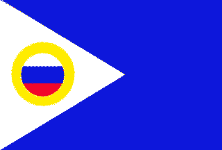
It consists of a 1:2 azure field, with a 1:1 white triangle in the hoist (i.e., this triangle is defined by the intersection of the flag’s diagonal lines), charged with a roundel of the russian flag fimbriated yellow.
On a website published full official text (in Russian) of new edition of the Law of the Autonomous Region of Chukotka #04-OZ (=okruznoy zakon, law of district) About Flag of Autonomous District of Chukotka, adopted on February, 19, 2004. In appendices to the law are published.color images (averse and reverse) of a flag and his graphic circuit
The flag of Chukotka in Russia marks its loyalty, and its
geographical character. The flag is symbolically blue, standing for
the water surrounding Chukotka and its rivers. It also stands for
the Chukchi people, as their national colour is blue. The white in
the hoist is representative of the ice, and snow, covering Chukotka
for most of the year. And to prove the region as a part of Russia,
this design includes the simplified version of the region coat
of arms, that has the Russian flag in the center surrounded by yellow,
and it being in a circle, indicating sun, hope and friendship.
Muhamed Mesic, 16 Nov 1998
.gif)
I noticed that Wrangel Island has it’s own
postal issues. Has this
island any form of autonomy and consequently flag?
Jaume Ollé, 06 Aug 1999
No. Wrangell Island (острова
Врангеля) is part of
Chukotka. Those stamps are issued by the Russian Postal authorities in Moscow
and sold to in a few central post offices. The closest to Wrangel Island that
those postage stamps ever get is in the album of japanese or alaskan
philatelists… There may be a flag for Wrangell island (rather the flag
of the local town — although I doubt it),
but it would have nothing to do with those postage stamps.
António Martins, 07 Aug 1999
Anything below this line was not added by the editor of this page.